India and Adjacent Countries

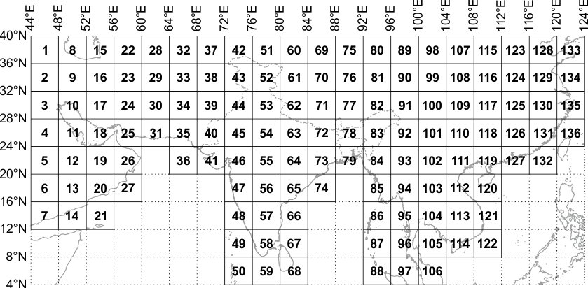
'India and Adjacent Countries (IAC)' is a regional and arbitrary system for India and adjoining countries (largely those under British control/influence or of interest, during pre-independent India).

Topographical maps under this series was prepared by the Survey of India till the coming into existence of Delhi Survey Conference in 1937. Henceforth, the preparation of maps for the adjoining countries was abandoned and the Survey of India confined itself to preparing and publishing the topographical maps of India as per the specifications laid down for the International Map of the World Series. A map numbering system was developed to give each map a unique number.

The map series is based on Polyconic projection on Indian Geodetic Datum.

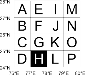
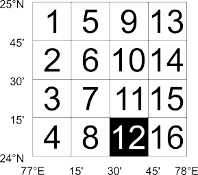
Map numbering is of the form '12A/1':

  1. The first number indicates a 4°×4° area, with numbering increasing from north to south and then from west to east, beginning with 1. The north western corner of this 4°×4° grid is at 44°E 40°N, but empty regions are skipped (refer layout below). So sheet with Kalyanpur (77.65489°E 24.11981°N) would be in '54':
    India and Adjacent Countries (IAC) map numbering 4°×4° index
  2. Each 4°×4° square is divided into 16 squares of 1°×1°. Each square is indicated serially by an alphabet increasing first towards south and then towards east, starting with 'A'. So sheet for Kalyanpur (77.65489°E 24.11981°N) falls within '54H':
    India and Adjacent Countries (IAC) map numbering 1°×1° index of 4°×4° - 54
  3. Each 1°×1° square is further divided into 16 squares of 15'×15' (15 minutes×15 minutes). Each square is indicated serially by a number increasing first towards south and then towards east, starting with '1'. So for the map sheet for Kalyanpur (77°39.293'E 24°7.187'N) would be '54H/12':
    Countries (IAC) map numbering 15'×15' index of 1°×1° - 54H

India and Adjacent Countries map numbers are especially used by Survey of India maps, especially those printed before adoption of the Open Series Map/Defence Series Map.

To view the distribution in Google Earth download this KMZ.

Lookup India and Adjacent Countries map numbers in Map Number Lookup.