Deesha depends on your device GNSS (Global Navigation Satellite System)/location sensor to get a location fix.
Acquiring a location may take time, especially for the first time. Make sure that you are in open area with a clear view of the Sky and least structures around to get the best possible signal reception from satellites.
You should check the following:
Under the device 'Settings > Location', for 'Mode', 'High Accuracy' or 'Device Only' is selected. These settings (name/wording) may vary a little as per your manufacturer. Deesha should by default warn automatically if the GPS sensor is disabled and direct you to this settings page.
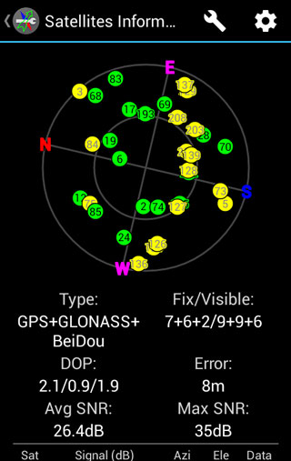
If you fail to get a satellite fix then... Once you start Deesha open 'Tools > Satellites Information'. Are there any satellites being displayed in the Sky/Earth View? Also, check if any are being shown in the listing below the Sky/Earth View: Satellite Information Screen showing satellites in use/view
You can also try to clear and request download of the 'A-GPS Data'. To do this under the Tools option click 'Clear A-GPS'. After resetting you can do a 'Request A-GPS' to manually request download of A-GPS data. Download of A-GPS data needs an active internet connection.
Unless there is some other issue with your device GNSS sensor the above should enable you to get a fix.
Location reported by Deesha is not accurate!?
Location accuracy is not by the app, but is dependent on the GNSS sensor of your device.
As per my own testing, smartphone GNSS (Global Navigation Satellite System)/location sensors (GPS and in some cases GLONASS/BeiDou/Galileo also) provide sub 10m accuracy with favourable conditions. Commercial GNSS (GPS/GLONASS/BeiDou/Galileo) receivers provide *slightly* better accuracy but have certain other advantages. However, the position being reported by two different device will differ by a larger degree as it is a combination of the errors of the two devices.
In case you are comparing Deesha with a commercial GNSS device using the Indian Grid, do ensure that the correct datum is being used. Unfortunately some such devices do not have support for the correct datum (Garmin being one, which only has 'Indian (Bangladesh) datum which can lead to an error of upto 15m!). Also there may be variation in the parameters being used leading to a difference in coordinates. A fairer comparison of the accuracy would be to use the same location format and datum on the GNSS device and your mobile device, say for e.g. Geodetic system (Longitude/Latitude). With the Geodetic coordinates, 1 second of Longitude will correspond to approximately 30m in southern parts of India and 25m in northern parts of India and 1 second of Latitude will correspond to approximately 30m.
Compass not working in Deesha when stationary!
Compass working in Deesha only when moving!
Deesha depends on your device magnetometer/magnetic/compass sensor for the graphical compass feature to work (and show heading).
Most devices have such sensors but there are some device which lack such sensors. Deesha should by default warn automatically on starting about lack of a compass sensor on devices without a compass sensor.
Without a compass sensor, the graphical compass feature and heading will not work while the device is stationary. While on the move, the heading will be computed with the help of the GNSS sensor and also shown by the graphical compass.
Does Deesha support GAGAN/SBAS?
Why does my device not support GAGAN/SBAS?
Support for GAGAN (GPS Aided Geo-Augmented Navigation System) or any other SBAS (Satellite Based Augmentation System) like WAAS, EGNOS, MSAS etc is completely dependent on your device hardware.
The good news is that most modern devices support SBAS. Also, GAGAN is compatible with other SBAS and should work if your device supports SBAS.
In case your device does not report GAGAN or any other SBAS, it most probably does not support the same.
Are IRNSS/NavIC & Galileo supported by Deesha?
Deesha's ability to support IRNSS (Indian Regional Navigation Satellite System)/NavIC (Navigate using Indian Constellation), Galileo or any other future GNSS (Global Navigation Satellite System) is total depended on the hardware of your device.
Once devices hardware start supporting IRNSS/NavIC, Galileo; Deesha should be able to seamlessly use them via the Android API.
Note: You can check which all GNSS constellations are supported by your device from the manufacturer's website or from sites such as GSMArena.
I have a 6/8/10 Grid Reference/Coordinate (Indian Grid System) and Deesha does not accept it!
A full Indian Grid coordinate consists of seven digits of both Easting and Northing (refer Expressing a Location). However, it is at times expressed with lesser number of digits for brevity, with a common system being omitting first two digits of both. Deesha requires you to enter the complete Easting/Northing values.
In case you do not have the complete values you can extrapolate them by doing the following :-
While specifying a location, click the button 'Current Location' or 'Last Location'. This will replace the Easting/Northing with the current/last values respectively. Note: Make sure this is indeed correct!
Keeping the first two digits for both Easting and Northing, enter the coordinate values with you.
If required, complete the Easting and Northing values with zeros in the end to get total of seven digits for both. You'll need to fill two zeros in case of six figure coordinates and one zero in case of eight figure coordinates, for both Easting and Northing.
For e.g.:
The coordinates with you are 876543 (six figure coordinate) i.e. Easting 876 and Northing 543.
Say after replacing with current/last location, the result is:
Easting
:
1234567
Northing
:
3456789
Keeping the first two digits, delete the other digits:
Easting
:
12
Northing
:
34
After the first two digits, enter your values:
Easting
:
12876
Northing
:
34543
As required complete Easting and Northing values with zeros in the end to get a total of seven digits for both:
Easting
:
1287600
Northing
:
3454300
Note:
The above will not give you correct results if the first two digits of either the Easting or Northing are different for current/last location and the coordinates you are trying to specify. Refer to the figure 'Confusion while omitting first two digits of Easting and Northing' in Expressing a Location.
An indication of this could be if the first digit of Easting/Northing of your last/current coordinate is '0' and the first digit of Easting/Northing of the coordinate your are specifying is '9'; or vice-versa (i.e. '9' & '0' respectively).
How to import Waypoints to Deesha from Google Earth?
To simplify and speed up the process of creating Waypoints in Deesha, Google Earth can be used to mark locations of interest i.e. Waypoints. The marked locations can then be saved in a KML (Keyhole Markup Language) or KMZ (Keyhole Markup language zipped) file, which can be copied to the device storage and then imported to Deesha.
First, open Google Earth.
Now create a folder to keep all your locations together. This will also make the process of exporting the locations from Google Earth to a KML/KMZ file simpler. To do this...
First make sure that 'Side Bar' is visible on to the left of Google Earth. If not check under 'View' Menu. Alternatively, press the shortcut key of 'Ctrl+Alt+B' in Windows.
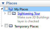
Make sure the 'Places' tab is expanded like this:
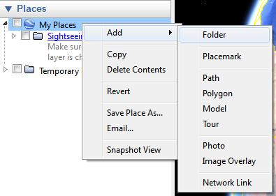
'Right click' on 'My Places'...
...and select 'Add > Folder', to create a new folder.
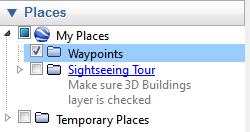
Name the new folder as 'Waypoints' or any other name as desired:
In Google Earth, navigate to the location to be mark. It is suggested that the view is 'straight down' and not 'tilted' to get accuracy while marking location. View can be reset to remove tilt by pressing 'R'.
While keeping the location to be marked in the centre, click the 'Add Placemark' button (or use the keyboard shortcut 'Ctrl + Shift + P' in Windows) on the toolbar:
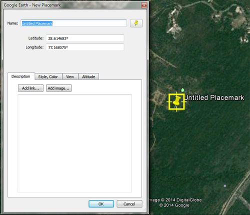
A Placemark will be placed with a yellow pushpin as the default icon at the centre of the view:
Edit the Placemark name and location (Longitude/Latitude). The Placemark can also be moved by dragging with mouse to adjust its position finely.
Mark more Placemarks on required locations by repeating Steps 8 to Step 11, ensuring that they are added in the folder created in Step 7.
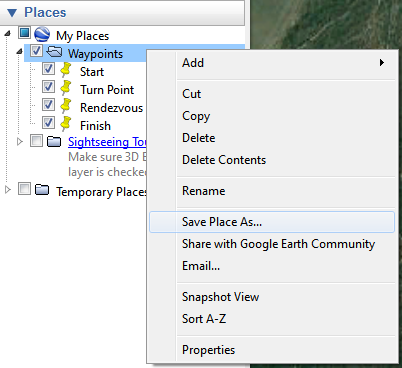
Once all the locations are marked, right click on the folder created in Step 6-7 and click 'Save Place As...':
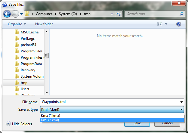
Specify a filename. In 'Save as type' choose either 'Kml (*.kml)' or 'Kmz (*.kmz)', remembering your choice:
Transfer the saved KML/KMZ file to the device storage.
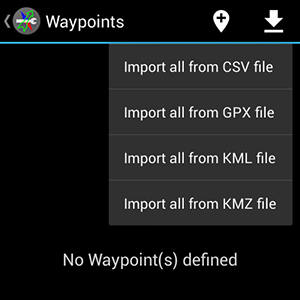
Open Deesha and from the options menu open 'Waypoints' screen. On Waypoints screen from the options menu select 'Import all from KML file'/'Import all from KMZ file' depending on the file type you selected in Step 14:
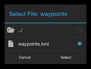
Browse to the location of the file on the device storage and select to import:
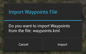
Alternatively you can click on the file directly with your device file manager. This will open Deesha with option to import the file:
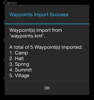
Waypoints from the file will be imported:
Note: Any duplicate waypoints (having same name as a previous waypoint) will be skipped.